
This month we’re publishing Wild Swimming Sydney Australia. Here the authors, Sally Tertini and Steve Pollard, reveal the most beautiful and stunning outdoor swimming spots in and around Sydney:
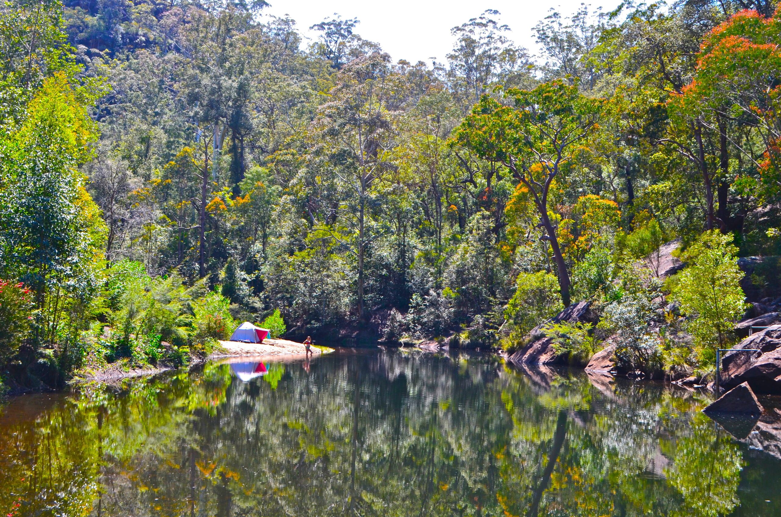
Erskine Creek at Jack Evans Track, Great Blue Mountains South (above)
This is such an enticing place to escape the city and spend a weekend – a 200m pool bordered by a large sand bank that’s perfect for pitching a tent or two. The bush seems to melt right into the pretty pool, and compared to many swims in The Mountains it’s a cinch to get to! Sculptured cliffs loom over the deep water, and little swallows dart above its surface, harassing dragonflies. In the morning you’ll be awoken by a joyful assault of birdsong – when all the birds of the valley chime at once.
You can pepper a couple of idyllic days with lazy swims right here, but for the more adventurous it’s also possible to amphibiously explore up and downstream.
Facilities: Campsite
Seclusion: Average-secluded
Navigation: Easy-moderate
Descent: 170m
Walk-in: 50 mins, 1.35km, moderate. From the S end of Bruce Rd, Glenbrook, pass the NPWS entry station (vehicle entry fees apply) and continue to cross the Glenbrook Creek causeway, where the road becomes The Oaks Fire Trail. Keep to this main trail, ignoring turn-offs. After 8km this passes the Oaks Picnic Area and becomes the Nepean Lookout Trail. After 11.8km there’s a car park on the R at the end of the trail. Take the track beside the info sign. After 200m there are views over the gorge. Hereafter, the track descends moderately to the creek. At a fork in the track just above the creek bear L downstream. You’ll soon see the sand bank on the other side of the creek. After a further 140m, cross over the creek at rapids and walk back upstream to the sandbank. There’s also a large campsite set back in the trees. Note: this pool can get a bit stagnant during drought. However, 125m upstream from the fork is a smaller pool bounded by large boulders, which remains fresh and has a small campsite for a tent or two on its far bank. -33.8475, 150.5766

MacCallum Pool, City and Harbour (above)
What an enviable harbourside position: on a Monopoly board MacCallum would be one of the dark blue properties. Tucked as it is below the Morton Bay fig-lined slopes of manicured Cremorne Reserve, it has superb views across the harbour to the Royal Botanical Gardens and Opera House. You may want to mirror the famous arc of the Harbour Bridge with your freestyle arm as it looms in the distance.
Occupying such prime real estate hasn’t affected any of the egalitarian ethos that accompanies Australian rock pools – MacCallum really feels like it exists for everyone, and its casual and welcoming atmosphere makes for a laid-back swim. The water is the most enticing shade of luminous green, like lime cordial, especially when the sun catches it (afternoon is best). This is a special place you should swim in at least once!
Seclusion: Busy-average Walk-in: 5 mins, 200m, easy
The 30m pool is flanked by a wooden boardwalk, which is raised up from the water, so that as you swim you can spy harbour life unfold before you: ferries zigzag through the water and the white triangles of sailboats glide silently by. Closed one day a week for cleaning. See: www.northsydney.nsw.gov.au
Via path off Milson Rd, Cremorne Point, just N of junction with Rialto Ave. 50m. -33.8452, 151.2280

Glenbrook Gorge, Great Blue Mountains South
In the equation of reward for effort, this is an absolute winner! In every direction the craggy forms of orange and charcoal cliffs rise up towards the sky, hemming you in. You get to swim among this sensational scenery, and yet the walk in is as easy as mountain walks get!
Before reaching the Nepean, Glenbrook Creek first snakes its way between the sandstone ledges and boulders that dominate the gorge. There are channels of interconnecting rapids to play in, dramatically situated, intimate pools, or larger, deep pools for splashing about with friends. Since the gorge runs roughly east-west, the pools get a lot of sun throughout the day.
The gorge is a little too obscure to be visited by the masses of tourists that descend on The Mountains to swim at the nearby, famous Jellybean Pool. Yet at the same time, the walk is not quite challenging enough to entertain the bush-walking set. This means that the gorge is surprisingly little-visited, and the beauty of this place is that once you reach the creek you can walk as little or far as you fancy.
Seclusion: Average
Navigation: Moderate
Descent: 120m
Walk-in: 60 mins, 1.7km, moderate. From the Glenbrook NPWS Visitor Centre car park (vehicle entry fees apply), at the S end of Bruce St, Glenbrook, take the road in the bottom-L corner signed Works Depot. After 60m bear R onto Gorge Track. This descends moderately with steps, arriving at a junction close to Glenbrook Creek after 500m. If you turn R here, and then immediately cross the creek over the shrub-covered boulders, on the other side there’s a large rock shelf beside a nice, long pool containing some big boulders. Otherwise, continue L downstream, first along a path and then along rock shelf. After 800m there’s an easy place to cross where the creek is squeezed between two low boulders in the creek bed – this also happens to be at the start of the gorge – where rocky cliffs come down on both sides. Continue downstream on the shelf. After 1.2km there’s a shallow pool nestled among giant boulders. For a while after this pool there’s a jumble of boulders and shrubs – it’s easier to continue walking near the cliff. After 1.5km the rock shelf ends at a cliff. You may have to cross the creek then re-cross back again. 30m further on there’s a long, open pool in spectacular gorge scenery. After 1.7km, there’s a large, deepish pool below the cliff on which the train line runs. Glenbrook Station 1.3km. -33.7826, 150.6288

Wentworth Falls, Great Blue Mountains South
If you need to clear out the cobwebs, a swim beneath these awe-inspiring falls will definitely do the trick! As the falls loom from 187m above, you’re immersed in cold water amid a near-deafening rumble; the thrill of it all will leave room for nothing else. The walk down to the bottom of the falls has stupendous views over Jamison Valley, with the cliff-side track providing one of the most spectacular vantage points in all of the Blue Mountains. Part of the track was made over a hundred years ago by the “Irish Brigade” – a dedicated but clearly crazy lot, who cut steps into the sheer sandstone cliffs to enable safe access into the valley. It’s difficult to imagine a steeper walk – the last section involves a series of near-vertical caged ladders, but your efforts are rewarded!
The constant boring of the water plummeting from the falls onto the rocky floor below has created a small pool. Despite the water being bracing even in summer, it’s an extraordinary setting for a dip! Swimming allows you to get right up close to the falls – the water billows out, illuminated by the sun, before dropping into the pool hard and fast. Sometimes it feels like a wondrous massage, at other times its sharp points drill into your skin and burn; yet the ebullient experience will leave you wide-eyed and buzzing!
Seclusion: Busy-average
Navigation: Easy-moderate
Descent: 280m
Walk-in: 90 mins, 2.3km, hard. Via car park at end of Falls Rd, Wentworth Falls. The walk starts from the info sign near Jamison Lookout. Continue L, signed to Walking Tracks. After 270m you arrive at Wentworth Falls Lookout. The walk takes you down into the valley below the falls. Bear R down the steps signed The Falls and National Pass. This descends gently, and after 620m turn R at T-junction. The steps become steeper from here. After 660m arrive at Fletchers Lookout, which has great views. Turn L and then at Y-junction after 690m, continue R to The Falls. Soon after you cross Jamison Ck with steppingstones, after which the stairs become even steeper. Soon, after 1.2km, you arrive below the first set of falls, then cross back over the creek. The track then winds its way around the edge of the cliff away from the falls. After 1.6km take the steps sharp L to Wentworth Pass / Valley of the Waters via Slacks Stairs. This descends seven sets of metal ladders, before switching back L to the base of the second set of falls, where the pool is. Wentworth Falls Station 2.4km. -33.7280, 150.3728 =

Morong Falls, Great Blue Mountains South
Kanangra-Boyd National Park is so vast and untamed that it completely dwarfs you. Swimming here, in a deep pool, surrounded by it all, you become a tiny dot. The creek pauses to catch a moment’s breath in the pool, before continuing to hurl itself through the wild, primal landscape. The setting is spectacular, with weighty, imposing granite boulders and the roaring white Morong Falls, which tumble relentlessly. Thanks to the pristine nature of this wilderness area, the dark water is so clean you can drink straight from the pool! It’s a delightful place to spend the day – so many waterfalls are fern-encrusted and damp, but here the sun will warm you on your pick of boulders.
If you take your time and exercise caution, it’s possible to scramble down the craggy rock drop-offs that the creek tumbles over. Without too much effort you can make it down to the top of the final epic drop-off, which offers a stunning, if dizzying, view of Morong Deep. There are smaller pools below several of the upper waterfalls, which offer further swimming opportunities. Most of the walk here is on a well-maintained fire trail suitable for mountain biking, so if you’ve got wheels getting here would be easy.
Seclusion: Secluded
Navigation: Hard, Kanangra + Shooters Hill GR 765361
Descent: 130m
Walk-in: 90 mins, 4.3km, moderate. From Jenolan Caves Rd turn onto unsealed Kanangra Walls Rd, Kanangra- Boyd NP. Continue for 14.9km, then turn R onto Kowmung River Fire Trail. Reset odometer. After 5.4km turn L onto Morong Creek Fire Trail. Then, after 7.9km, park before a creek crossing. Start the walk by crossing the creek and continuing along the fire trail. After 350m turn R onto Morong Falls Fire Trail. After 1.6km continue through a locked gate. The trail gently undulates before ending at a turning circle. Take path R at 2 o’clock. It’s faint and rough, but you soon should hear the sound of the falls. Heading just to the L of them will bring you to the pool after 250m. Be careful to note where you’ve come from. -33.9798, 149.9932

Dunns Swamp, Great Blue Mountains North
This 3km serpentine length of water is bordered by cliffs, rock pagodas and pockets of reeds in which moorhens hoot and dragonflies flicker. Known as “Ganguddy” to the local Wiradjuri people, the name Dunns Swamp is a bit misleading as it’s actually a dammed section of the Cudgegong River, with deep, dark brown water that feels silky on the skin. Dunns was created in the 1920s to provide water for Kandos cement works, yet despite its industrial beginnings the landscape is striking – and it’s a smashing place for a swim!
One thing you notice about Dunns is that it’s startlingly quiet – with water so still there’s not even the usual faint babble, just a sprinkling of chirruping birds filters through the thick silence. The absolute stillness of the water also make it excellent for settling into a meditative rhythm and swimming leisurely along its length, or dropping a lilo in for a lazy paddle. The river adjoins a large busy campground, but you shouldn’t have trouble finding a place to yourself if you’re seeking solitude. Although jumping and diving are prohibited throughout the entire Wollemi National Park, it hasn’t gone unnoticed that the rock ledges jutting out over very deep water are seemingly made for it – one spot facing Platypus Point is particularly popular.
Facilities: Toilets, picnic tables, wood BBQs (fees), car-based campground
Seclusion: Busy-average
Navigation: Moderate
Ascent: 10m
Walk-in: 20 mins, 900m, easy. If you’re up for a bit of a scramble, the impressive, far-reaching views from the pagoda lookout are worth the effort. Camping fees apply – contact NPWS. From unsealed Narango Rd, Olinda, follow signs to Wollemi National Park. From the main car park turn L along the track signed Weir Walk. After 370m you reach Platypus Point, where low rock juts out into the water. This is a good place to swim. Continuing on, after 100m the track bends sharp R, then descends into a little dip. Shortly after ascending again, take the small path R. This leads after 300m to the R-hand side of a narrow-necked peninsula where there’s a cliff that leans out over the water 900m. The other side of the peninsula is just 75m away, and is very pretty and also a quieter spot for a swim. -32.8349, 150.2014

Emerald Pool, Central Coast and Newcastle
A delightful oasis of tranquil coolness in the harsh Australian bush – you could never guess of its existence, as it appears out of nowhere. It’s a lovely place to while away a summer’s day.
Hominy Creek pitter-patters into the pool, and the gentle sound is reminiscent of someone running a bath. The creek’s catchment is entirely within Popran National Park, so the water’s pristine. The pool has a delightful feeling of being tucked away, thanks to the surrounding rock ledges with their banksias and blackboys. Emerald has a tangible Aboriginal history, as just down the creek bed there are a number of axe-grinding grooves and animal etchings. You can place your hands in the grooves and trace the movement of their makers. It’s quite something to swim somewhere that’s been used for thousands of years! Please tread lightly and look after this special place, so it can continue to be enjoyed for generations to come!
Seclusion: Average
Navigation: Easy-moderate
Descent: 150m
Walk-in: 65 mins, 3.55km, easy-moderate
The pool is only about 15m, and though small, it’s incredibly beautiful. The water really is a remarkable emerald green, and when the sun hits its surface, the colour is startling! The sandy bottom and brown yabbies that march, scanning the pool with their little nippers, can all be seen in perfect detail, as though you’re looking through glass. The track is exposed with little shade. Via car park at end of Ironbark Rd, Mangrove Mountain. The last 3.5km are unsealed and there’s a rough, steep section 850m from the end, which may be unsuitable for 2WD vehicles. From the car park go through the locked gate and walk down the Mt Olive Trail. At the fork after 300m turn L, ignoring the path on the left to Mt Olive after a further 20m. The fire trail descends gently with a few steeper sections. After 2.6km turn R onto Hominy Creek Trail. After 3.45km you arrive at Hominy Creek. Cross over and walk L, downstream a short distance to the pool. -33.4028, 151.1718

Resolute Beach, Sydney North
The water here is so fantastically clear and appealing that you’ll want to fling yourself into its green sparkling depths mid-way down the many steps that lead to it! The low isthmus of Palm Beach extends across the horizon, and offshore boats pace backwards and forwards, with the beach itself being a popular place to drop anchor. This is a little paradise, but arrive early if you want it to yourself!
Seclusion: Average
Navigation: Moderate
Descent: 170m
Walk-in: 45 mins, 2.2km, moderate. Stowed away inside the entrance to Pittwater and shut in by steep bush, the west-facing beach is lapped apathetically by calm water – much calmer than Flint & Steel Beach just around the corner. Follow West Head Rd, Ku-ring-gai Chase National Park (vehicle entry fees apply), for 12.6km, then park in signed car park on R. Take the track signed Resolute Beach. After 400m this passes Aboriginal engravings on the L. After 950m turn L at fork. After 1.95km turn L off fire trail down steps to beach. After 2.1km with the beach in sight, turn L. Alternatively it’s a 30-min walk N from ferry at Mackeral Beach. % Mackeral Beach Terminal 1.2km. -33.5848, 151.3066

Upper Kangaroo Creek, Sydney South
This walk takes in several bush pools – one of which is famous, the others are little known, but include one of the best in all of Sydney. Don’t expect to have beautiful Karloo Pool to yourself – it’s justifiably popular. The water is deep, but you can still see everything, including the resident eel who quickly shies away the second you dip your toe in. Low rock ledges to dry off on surround the 35m pool, and the bush is flush with banksias and bottlebrushes.
It’s easily the most visited waterhole in Royal National Park – enthusiastic swimmers rip off their clothes and launch into the water, thrashing out a requisite lap before floating on their backs. Others paddle about with hushed reverence – but if it’s quiet you’re seeking, best come mid-week or carry on downstream.
Here you pass a couple of smaller pools rimmed by red aquatic grasses. And as you swim, you zoom over twisted tree trunks far below, like the ruins of ancient fallen cities. The end destination is Olympic Pool – the stuff of wild swimming dreams. This 50m pool has deep, clear green water that shimmers kaleidoscopically with the iridescence of an abalone shell. There are plenty of rock ledges for laying out on and a few from which to plunge into the water. Dragonflies pace up and down as if composing love sonnets and the place breathes with a gentle calm. Perhaps most incredible of all is that nobody seems to know about it! Please look after this special place.
Seclusion: Average-secluded
Navigation: Moderate
Descent: 150m
Walk-in: 90 mins, 3.9km, easy-moderate. The creek here is characterised by astonishingly clear water, coloured as if it were distilled from leaves of the surrounding trees. It’s enough to make your jaw drop – it really is that pretty! From S end of Wilson Pde, Heathcote, take track L, 40m past the Rural Fire Brigade, signed to Karloo. This runs flat behind backyards for 270m before forking off R. Soon after, you start to descend gently, crossing a small creek after 840m. After 1km continue straight over a large, sloping rock. For 1.8km the track is quite level, but thereafter it descends. Arrive at Karloo Pool after 2.4km. To explore downstream, cross over to the rock-shelf on the far side of the pool and follow the path. After 550m you’ll arrive at second pool. After 1km you’ll arrive at a similiar third pool. After 1.1km the unsigned Bottlebrush Forest exit appears on your L; ignore and after 1.5km you arrive at Olympic Pool. Heathcote Station 300m. -34.0918, 151.0296 v

Northern Booderee National Park Beaches, South Coast
Such is its renown, that at the mere mention of Jervis Bay, people glaze over, transported to a happy place. And with such beautiful beaches, it’s little surprise! If you want yours to be the first footprints on the sand, or you want to experience the delights of these beaches without other visitors, you may need to have a sunrise or sunset dip. At these times the light becomes warm and golden, and the tranquillity of Booderee National Park is enlarged.
Although indistinguishable in many ways from its more famous neighbour Green Patch Beach, Iluka is much less crowded and the water is astonishingly clear. So if you don’t need the facilities, this is a better destination.
From Jervis Bay Rd, Booderee National Park. Vehicle entry fees apply and permits are valid for 48 hours (NSW NP annual passes are not valid)
Facilities: Toilets, picnic tables
Seclusion: Average
Walk-in: 2 mins, 150m, easy. Turn L 4.5km from park entrance and follow signs to Iluka car park. -35.1333, 150.7171

Wild Swimming Sydney Australia: 250 Best Rock Pools, Beaches, Rivers and Waterholes by Sally Tertini and Steve Pollard is available to buy from Wild Things Publishing.
Areas covered include:
1 City & Harbour
With the sparkling emerald waters of Port Jackson
cutting through its centre, Sydney really is
The Harbour City!
2 Sydney North
North of Sydney Harbour, you can have the best of
both worlds – swim in the serene waters of Middle
and North Harbours, Pittwater and Broken Bay, or
take a dip in rock pools fronting the unbridled Pacific.
3 Sydney East
Right on the doorstep of the city, 30km of coastline
with tantalising aqua water and a string of fantastic
beaches and rock pools awaits!
4 Sydney South
Bay, beach and bush – there’s something for
everyone, including the most secluded swims
within Sydney’s city limits!
5 lllawarra
This area has a magic of its own – locked
between sea and escarpment, its scenery is
striking and unforgettable.
6 South Coast
The beaches here lay claim to having the whitest
sand in the world, and set against the area’s
impossibly clear water they certainly dazzle!
7 Southern Highlands
The cultivated charm of the quaint townships, rolling
farmland and vineyards for which this area is known
gives way to bush of dramatic and rugged beauty,
which abounds with memorable places to swim.
8 Sydney West
While not large in number, the swimming spots that
do exist here are big in size!
9 Greater Blue Mountains South
Named for the characteristic blue haze that shrouds them,
the World Heritage-listed Blue Mountains are as vast as they
are beautiful.
10 Greater Blue Mountains North
This is the region for the truly adventurous – for those that are
compelled to explore around the next bend in the river, and the next…
11 Central Coast & Newcastle
Change down a few gears and explore this sprawling
coastline and the region’s sheltered inland waters.
Here it’s easy to take it easy!