
Britain is bubbling with glorious little river and lake swmiming holes, all of your own. They are there for the finding, but how to go about it?
1) Hotspots: Focus on the wild swimming hot spots: areas likely to be rich in natural pools and clean unpolluted waters. Nature Reserves or National Parks are a good place to start and an internet search or basic guidebook will give you an initial list. Avoid areas downstream of large cities and settlements.
2) Maps: Try to obtain a good map of the area before you go. Try www.stanfords.co.uk, the worlds largest map store. You can also find a surprising amount of mapping free online. The UK now offers all Ordnance Survey scales for free through www.multimap.com
3) Terrain: Mountain areas will be dramatic with waterfalls, gorges and tarns and the cleanest of waters, but the water will be cold, good for short and exhilarating plunges only. Lowland areas will have warmer winding rivers and lakes, better for a longer swim, but with a greater possibility of bugs and beasties.
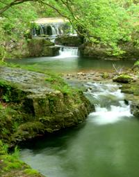
4) Features: You may find old weirs which create pools in rivers otherwise too shallow for swimming. Or examine the bends of rivers, where the inside often creates a beach while the outside deepens into a deep pool. Bridges are often built where the river naturally narrows into a gorge, and these can make excellent plunge pools for bridge jumping! Bridges, fords and riverside tracks indicate there will be few problems with access or trespass.
6) Local advice: Kids are the experts of wild swimming, ask them where they like to swim when it’s hot, or if there are some good jumping spots. You can also ask where people go to wash clothes or bathe, or ask older people where they learnt to swim. Rafting, kayaking, coasteering and canyoning companies will know good locations, so why not join a day trip.
Ask around: some older folks may remember when a local river or lake was used for swimming in hot summers of the past. Younger people too often know a good place to jump in, go for a plunge or find that ubiquitous blue rope swimng tied to a tree. Fishermen and kayakers are also good sources, as our keen walkers.
Look for clues on a map: why not follow a river along its length? Many have footpaths that follow the bankside. Buy an Ordnance Survey map of your area (Purple Landrager 1:50,000 or Orange Explore 1:25,000), or use www.multimap.co.uk online. They will identify all the water features in your area. Weirs are marked and swimming is often popular in the pools above or below. Bridges sometimes cross sections where the river naturally narrows and deepens, so examine these. Bends are always good, as the river shallows to a beach on the inside, but deepens to a pool on the outside. Legal access is important so also examine footbridges, riverside footpaths, road fords and other places where a right of way comes into contact with the water. In highland areas look for any mountain lake and examine waterfalls, where marked.
OS Landranger (purple) mapping is available at www.multimap.com. The larger scale Explorer (orange) mapping provides much more information at www.ordnancesurvey.co.uk/getamap.
Look online:
Try looking at www.ukriversguidebook.co.uk, which is dedicated to canoe and kayak users but may provide inspiration for your local area. www.uklakes.netlists many lakes in the UK. Many are used for watersports or fishing, but perhaps you can find your own secret little corner?
RALSA, the UK body promoting river swmiming and lake swmiming in the UK also has a very good list of places to swim, especially those compiled by Rob Fryer’s Cool Places. Swimming Holes Wales also provides a good resource for Wales.
You can look at our own Wild Swimming book or Google wild swim map or explore the map at the Outdoor Swimming Society. Lidos and tidal pools can be found at Oliver Merrington’s excellent lidos.org.uk webpage pages.
Do check the ‘water quality targets’ before you dip. Find data on your local river at www.environment-agency.gov.uk/ maps. These can be a bit fiddly but our guide will explain how they work.
Hi,
I just want to back up what has been said above. My top tips would definitely be OS Explorer maps. Look for waterfalls, weirs etc. The uks rivers guide book online is an awesome resources. Just been on a four week tour around Lake district and Scotland and found many spots using the online guides sampling 14 rivers or Lochs. Kayakers tend to use the rivers in higher water so don’t be put off by stories of extreme whitewater. Just check the levels of the water on evironment agency websites and go when its low to medium. The rivers in Scotland can change dramatically throughouth the year so be careful of high water. This summer most rivers where we have been have been low. At some swims we used buoyancy aids. Im not sure they were necessary but aided confidence and enjoyment. What was also useful was that we went rafting for a day and got some advice from the local guides.
We recently swam in Galloway Forest Park which had some nice plunge pools. Also the West Highlands to the east of Oban we sampled many rivers as well as the Etive in the book which was awesome!! Some nice lochs and waterfalls in the Argyll Forest Park to the west of Loch Lomond. I will try and add them to the map when I get the chance.
We are off to the Brecons tmrw to check out the Mellte after enjoying the Nedd fechan in the book!
Love your work
Ed
Thanks Ed for your useful tips. We will try and check out the Galloway tips on our next trip up to Scotland! Daniel
dank af
dank af
Watch In the Land of Women (2007) it Here!
This is nicely said. !
This is nicely put. .
You actually said that well!
Thanks a lot, Ample tips.